Thursday 28 January 2021

Wettest January in 12 Years

It rained heavily through the early hours of Thursday morning bringing the rainfall total for the month up to 81.6mm or 3.2in making it the wettest January of the last 12 years.
January Rainfall Records 2010-2021


Sunday 24 January 2021

Cold to Wet and Mild and Back to Cold

It's been a changeable week, to say the least. It began cold even though it was mild enough to melt the snowfall of the previous week. No sooner had the snow melted before storm Christoph arrived bringing with it milder wetter weather.
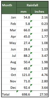
Rainfall - January 2021
Storm Christoph brought with it three days of rain, and, while none of the days brought us any record breaking amounts, with the snow melt it added up to 44.0mm (1.7in) of 'precipitation' in the week. It was enough to bring about some local flooding.
The beck through Rothwell Park was running high on Monday even before the arrival of storm Christoph.
The weather has now returned to colder conditions with Sunday morning recording the lowest temperature of the year so far with the thermometer falling to -2.8°C (27.0°F).

There's more wet weather forecast for the middle of the coming week so there's the possibility that this January could finish as the wettest January I've recorded in 12 years.

It isn't going to finish up the coldest January over the last 12 years. That record will remain with January 2010 which was particularly cold. It does however look as though it might finish up in the runners up position if the current colder conditions continue.


Sunday 17 January 2021

Wettest Day of the Month with Almost No Rain

Saturday turned out to be the wettest day of the month with my rain gauge measuring 16.2mm (0.64in) of rainfall. However, we only had a few light showers of rain and nearly all the rainfall can be attributed to the snowfall of a couple of days ago.

As the snow ceased on Thursday evening the temperature fell well below freezing, turning the snow very crispy. On Friday the temperature remained below freezing for most of the day so we had to wait until Saturday for the thaw to set in.
Temperature & Rainfall Records 14-16 January 2021

Looking back through my rainfall records for the last 12 years Saturday becomes the third wettest January day, this on a day when it hardly rained at all. It's the wettest January day since 26 January 2013 when we had 19.8mm (0.78in) of rainfall which is the wettest January day I've recorded.

The forecast is for much more rain on Tuesday and Wednesday so Saturday may not hold onto that record for very long. At the midpoint of the month, only January 2010 was colder so it looks like January is going to be cold and wet.

Friday 15 January 2021

A Bleak Midwinter Snowfall

It snowed all through the daylight hours on Thursday. As darkness fell we had quite an accumulation.


There doesn't seem to be much chance of a thaw starting today (Friday). It's 11:00am as I'm writing this post and the temperature is -1.4°C or 29.5°F. We are still waiting for the overnight mist to lift and hopefully reveal a little bit of sunshine.
The forecast suggests that some milder weather, mild enough to start a thaw, should arrive through Saturday.

There's a short video of Thursday's snowfall below.


Monday 11 January 2021

Ruby's First Birthday

It has warmed up a little bit since we took Ruby on her birthday walk around Nostell Priory. Strangely the grass was muddy but parts of the lake were frozen over.
Nostell Priory - 08 January 2021
The temperature today, Monday 11 January is hovering around the 6°C (43°F) mark but according to this morning's weather forecast, the milder temperatures aren't going to last with snow a possibility on Wednesday.

Ruby found as much mud as she could on her afternoon walk and was in need of a wash as soon as she got back home. She loves going for a walk, even in bitterly cold weather, but she's not at all keen on the wash that has to follow.


Friday 8 January 2021

A Major Sudden Stratospheric Warming Has Occurred

A Major Sudden Stratospheric Warming began around the 04 January. During the winter months, the stratosphere is extremely cold over the north pole. This sets up the Polar Vortex a strong westerly wind in the stratosphere which drives our winter weather giving us our usual strong westerly flow of winter weather.
https://ds.data.jma.go.jp/tcc/tcc/products/clisys/STRAT/index.html

The SSW has resulted in the reversal of the Polar Vortex from westerly to easterly. This may or may not eventually have an effect lower down in the atmosphere and bring a change to our weather. 

There's a better explanation of the nature of a SSW here.

Back on earth, our forecast is for the temperatures to gradually lift over the next few days to around average for January. We'll have to wait and see if that SSW brings a change to our weather. 


Wednesday 6 January 2021

A Cold December but Warm 2020

December 2020 finished up as one of the coldest Decembers I’ve recorded. It certainly didn’t match up to December 2010 which was a record breaker but other than that it was almost the coldest I’ve recorded.
Temperature & Rainfall Records Decembers 2010 - 2020

It finished up surprising wet too. I’d expect a cold December to be more on the dry side but that wasn’t the case. Of course, it’s meant the allotment is now too wet to do any digging. We’ll have to wait for spring and some drier conditions before we can begin cultivating the ground.
We visited the plot on Monday afternoon and there were still a few remnants of Saturday's snow about. We didn't hang about at the plot, staying just long enough to harvest some fresh vegetables.

I've also had a chance to sort out the temperature and rainfall figures for 2020 as a whole and see how the year compared with the last 10 years.

Annual Temperature & Rainfall Records for 2010 - 2020

I was surprised to find 2020 coming as around average over the last 10 years. It didn't seem that warm a summer to me. Looking back over the year I can see why, as the months with above average temperatures weren't the summer months.

Temperature Records for 2020

I've highlighted how the monthly temperatures fluctuated from the average in the red box above. January had the largest difference coming in 2.4°C (4.3°F) above the average for January and November also well above average. July, disappointingly was one of the months much cooler than average.

The current forecast is that the cold spell will continue for a few more days before temperatures return to more normal values for January.

Monday 4 January 2021

A Cold Start to the New Year

The coldest day of 2020 was saved for the very last day of the year. It was the only day of last year with an average daily temperature below zero coming in at -0.3°C or 31.5°F. The weather models were correct when they suggested a cold spell starting just after Christmas. 
Temperature & Rainfall Records 29 December 2020 to 04 January 2021
Daytime temperatures haven’t made it much above 0°C but luckily so far night time temperatures haven’t fallen much below freezing. 
We did get a few snow showers on Saturday. At one time on Saturday afternoon, it looked like the showers were going to give us a rather substantial snowfall but after a few minutes the snow eased up.


Whilst daytime temperatures have been below average it has been warm enough for the little bit of snow that did fall to thaw. However, the weather models are predicting that below average temperatures may well continue to around the middle of the month before somewhat milder weather arrives.