
I'm not sure of the official date when astronomical summer ends but weather wise Thursday saw our very dry summer come to a very abrupt end. The rain began reasonably gently early afternoon and continued through to almost midnight with some bouts of very heavy rain mixed in.
 |
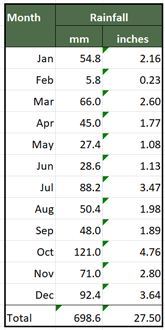
| Temperature & Rainfall September 2018 |
After a very dry summer Thursday saw a rainfall total of 41.6mm (1.64in), in less than 12 hours, making it the wettest day of summer. That's a typical month's rainfall in half a day! Since May we haven't had a monthly total as high as that. It's certainly brought our drought to an end. However, as you can see from the table below, it's also taken over as the wettest day we've had since 2010.

There seems to be a few instances of local flooding as drains not used to rainfall couldn't cope. We managed to find one such spot in Wakefield last night.

It will be interesting to see what effect all the rain has had at the allotment. Will we have gone from too dry to do any digging to too wet with almost one month's rainfall in less than 12 hours?
To add insult to injury it became very windy Thursday night into Friday morning with my weather station recording a wind gust of 30mph. That's another September record as it's the highest wind speed I've recorded in September.

The wind abated through the early hours of Friday morning and a quick look around the garden doesn't reveal any damage apart from a blown over bird feeder. That's now back in an upright position and the feeders filled up so the birds will be happy.
We'll have to plan a trip to the plot to check if there is any damage there and to see if soil conditions are suitable for digging or whether the ground will have gone from too dry to too wet. If the latter is the case we will have had an amazing turn around in the space of one day!


How exciting! Is this associated in anyway with the remains of a hurricane in the Atlantic"
ReplyDeleteSort of! The first storm of the week was Helene (ex hurricane or tropical storm) named by the National Hurricane Center. That just gave us some strong winds. The next storm in was named Ali by the UK Met Office and once again gave us some gale force winds. Then on Thursday it was storm Bronagh named by the Met Office. I think latter 2 storms formed out in the Atlantic rather than starting off as tropical storms/hurricanes in the South Atlantic. Bronagh brought us the wind and heavy rain. There's another system potentially for the weekend but the weather models are having trouble predicting its path or if it will develop into another storm.
DeleteWe caught Ali bigtime but Bronagh was a non event by comparison.
ReplyDeleteOpposite way round to us then. Looks like Sunday's rain is heading for the "south". Might have a visit to the plot on Sunday.
Delete